BSEE Tests Technology for Oil Spill Exercise in Arctic


With the Arctic expected to be a major source of oil and natural gas, the development and testing of technologies to detect and clean-up Arctic oil spills will remain a critical area of focus.
As part of this research, the Bureau of Safety and Environmental Enforcement’s (BSEE) Oil Spill Preparedness Division tested the capabilities of a geo-referencing identification satellite (GRIDSAT) technology during its inaugural participation earlier this year in Ice Exercise 2016 (ICEX). ICEX is an exercise designed to assess the operational readiness of the submarine force while also continuing to advance scientific research in the Arctic region.
The U.S. Navy has been running ice exercises since at least the late 1950s. Last year, the Navy approached BSEE about participating in the event, Karen Stone, an oil spill response engineer with BSEE’s Oil Spill Preparedness Division, told Rigzone.
“We’re always interested in partnering with other federal groups and combine all their expertise,” said Stone.
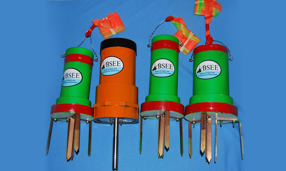
The GRIDSAT system is a new technology in the sense that it’s being used in a new application of existing components, Stone said. The Arctic’s extreme conditions, especially the presence of sea ice, create unique challenges for identifying, tracking and responding to an oil spill. Sometimes, oil trapped by ice cannot be recovered quickly due to weather conditions. The GIRDSAT radio/GPS marking device can be left on an ice floe to track the movement of the floe and entrapped oil for up to nine months.
A lack of infrastructure, especially communications infrastructure, is a major hurdle for companies operating in the Arctic. Stone said that most satellite systems only work at the mid-latitudes, where the world’s population is located. The geo-locating technology tested by BSEE communicates with the Iridium Satellite Network that is capable of operating at the poles.
BSEE tested the GRIDSAT system at the U.S. Navy’s Ice Camp Sargo, a temporary station on top of a floating ice sheet in the Arctic. As part of the tag project, BSEE deployed several marking devices on the ice floe for long-term duration studies. Two GRIDSAT tags with floe spikes were dropped from a helicopter, and one GRIDSAT tag was manually inserted using an ice screw technique, Stone said. Both methods would be used to tag and track oil either trapped under or encapsulated in Arctic sea ice.
Over the past 20 years, the size, weight and efficiency of sensors and satellite technology has gotten smaller, allowing for technology robust enough to operate in Arctic conditions, Sam McClintock, director of midstream technology at BSEE, told Rigzone. For the GRIDSAT tags with floe spikes dropped from helicopters, they were housed inside ice spikes. These spikes had to be designed to stick to and embed in snow and ice without bouncing off, like the front of a car in case of a crash.
The technology came out of a BSEE 2014 Broad Agency Announcement seeking ideas to address two projects: how to track oil spill assets and equipment, and how to track spilled oil trapped under or in ice as ice floes moved. BSEE wanted a way to direct assets and equipment located miles away from an oil spill, as the dark Arctic winter and harsh environment means that spilled oil sometimes cannot be recovered right away.
“We wanted to protect the environment, but we wanted to protect people even more,” Stone explained.
After conducting a thorough technical review, BSEE funded AECOM, previously known as URS, which proposed addressing both projects with the same technology. AECOM developed a prototype of an innovative, cost-effective and robust tagging device, alongside an automatic tracking system to locate oil spilled under or trapped within ice. This system uses lamb waves to assist in the tagging of oil under ice, Stone told Rigzone. Lamb waves are waves that propagate along a surface such as an ice floe, and can travel considerable distances.
The technology was designed to use minimal power to conserve energy and extend the tracking period. This system includes an underwater sphere placed with the oil, a GRID tag placed on top of the ice, and a user interface to track the location of the oil as it moves with the ice floe. The underwater spheres, which contain underwater geo-referencing identification tags, are designed to be placed in the oil under the ice. The tags release a lamb wave along the ice surface that is detected by the surface GRID tags.
BSEE conducted the test to determine the system’s limits. Stone told Rigzone that BSEE is still awaiting analysis of some of the GRIDSAT tests on the distance the lamb waves traveled through the ice.
“However, early indications are that the tests were very successful,” Stone commented, noting that the ice spike design was successful for both a helicopter drop and manual placement on top of the ice.
The ice test took place 250 miles north of Dead Horse, Alaska, well within the Arctic Circle. Camp for this year’s ICEX had to be broken early due to Arctic ice, which is melting quickly and at twice the rate of ice melting in the U.S. Lower 48, Stone said.
Resource Size to Keep Arctic on Future Exploration Map
Low oil prices, the challenges of Arctic exploration, and regulatory hurdles have slowed interest in Arctic exploration for some. Last year, Royal Dutch Shell plc shelved plans to explore the U.S. Chukchi Sea. In early April of this year, short-term cash flow priorities and consolidation after the BG Group plc acquisition prompted Shell to pull its application from Norway’s Arctic-focused oil licensing round.
However, the Norwegian Arctic is making a comeback after years of declining activity, Reuters reported April 21. While exploration plans in mature North Sea areas are being scuttled this year because of tighter budgets, the number of exploration wells planned for the Norwegian Barents Sea has increased to 10 this year from seven in 2015.
In addition, the size of the Arctic’s oil and gas resources – and the fact that the Arctic Continental Shelf is one of the least explored geological basins with potential for significant hydrocarbon discoveries – means that interest in Arctic exploration and production will likely remain in the long-term.
Arctic oil and gas activities to date have resulted in the production of more than 25 billion barrels of liquids and 550 trillion cubic feet (Tcf) of natural gas, according to the 2015 report by the National Petroleum Council “Arctic Potential: Realizing the Promise of U.S. Arctic Oil and Gas Resources.” The Arctic is also estimated to contain an additional existing reserve base of 38 billion barrels of liquids and 920 Tcf of gas. Additionally, the Arctic is estimated to contain another 525 billion barrels of oil equivalent (BBoe) of conventional resource potential, 426 BBoe of which is undiscovered conventional liquids and gas. This 426 BBoe represents approximately 25 percent of the remaining global undiscovered conventional resource potential.
WHAT DO YOU THINK?
Generated by readers, the comments included herein do not reflect the views and opinions of Rigzone. All comments are subject to editorial review. Off-topic, inappropriate or insulting comments will be removed.
- How Likely Is an All-Out War in the Middle East Involving the USA?
- Rooftop Solar Now 4th Largest Source of Electricity in Australia
- EU, Industry Players Ink Charter to Meet Solar Energy Targets
- US Confirms Reimposition of Oil Sanctions against Venezuela
- Analyst Says USA Influence on Middle East Seems to be Fading
- Brazil Court Reinstates Petrobras Chair to Divided Board
- Russian Ships to Remain Banned from US Ports
- EIB Lends $425.7 Million for Thuringia's Grid Upgrades
- Var Energi Confirms Oil Discovery in Ringhorne
- Seatrium, Shell Strengthen Floating Production Systems Collaboration
- An Already Bad Situation in the Red Sea Just Got Worse
- What's Next for Oil? Analysts Weigh In After Iran's Attack
- USA Regional Banks Dramatically Step Up Loans to Oil and Gas
- EIA Raises WTI Oil Price Forecasts
- Venezuela Authorities Arrest Two Senior Energy Officials
- Namibia Expects FID on Potential Major Oil Discovery by Yearend
- How Likely Is an All-Out War in the Middle East Involving the USA?
- Oil Markets Were Already Positioned for Iran Attack
- Is The Iran Nuclear Deal Revival Project Dead?
- Petrobras Chairman Suspended
- Oil and Gas Executives Predict WTI Oil Price
- An Already Bad Situation in the Red Sea Just Got Worse
- New China Climate Chief Says Fossil Fuels Must Keep a Role
- Oil and Gas Execs Reveal Where They See Henry Hub Price Heading
- Equinor Makes Discovery in North Sea
- Macquarie Strategists Warn of Large Oil Price Correction
- DOI Announces Proposal for Second GOM Offshore Wind Auction
- Standard Chartered Reiterates $94 Brent Call
- Chevron, Hess Confident Embattled Merger Will Close Mid-2024
- Analysts Flag 'Remarkable Feature' of 2024 Oil Price Rally